Snowstorm in NYC this weekend? What the models are saying now – NBC New York

Parts of the Mid-Atlantic and Northeast will contend with a coastal storm that could deliver some impressive snow totals to some areas this weekend.
Through Thursday afternoon, the forecast uncertainty remains high in terms of exactly how this storm will play out. Current long-range forecast models indicating very different narratives.
That said, there are a few things that are starting to become more clear.

What we know:
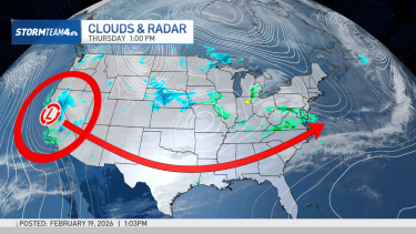
We know that an area of low pressure currently over California will traverse the country and move off the North Carolina coast on Sunday. As it moves into the Atlantic, the low will strengthen and the tri-state area will pick up light to moderate snow and gusty northeast winds beginning Sunday afternoon.
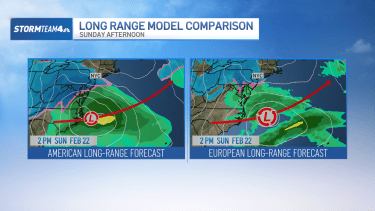
The American and European forecast models – two of the long-range models we rely on heavily for extended outlooks – are pretty consistent up to that point, with the low pressure area setting just off the Carolina Coast by early Sunday afternoon.

Snow will be light to moderate initially, with a dusting to no more than three inches of accumulation likely for the tri-state through Sunday afternoon.
What we don’t know:
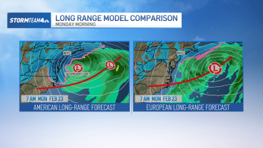
How the storm plays out Sunday night into Monday becomes a much bigger question. The long-range models deviate at this point.
The American model solution keeps the initial low pressure system on a track well offshore. However, as that low pulls away from the coast it predicts a secondary low will develop just off the Jersey Shore. That secondary low would produce a band of heavy snow Sunday night into Monday morning for the Delmarva Peninsula, South Jersey and possibly Long Island. Under this scenario, hardest-hit areas could pick up a total of 6 to 12 inches.
Conversely, the European forecast model keeps the main low moving on a track offshore but does not develop the same secondary low. Without that, there’s very little snow for Sunday night into Monday. The European model also shows snow totals for most areas would likely stay under three inches.

The bottom line:
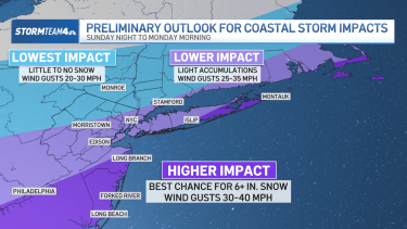
The forecast for Sunday and Monday continues to be very fluid. Do expect snow this weekend – light to moderate Sunday afternoon, with the possibility of additional heavy snow Sunday night into early Monday.
Areas most likely to see over six inches of snow would be South Jersey and Long Island, with lighter amounts to the north and farther inland. Also, expect gusty northeast winds, especially along the coast as this storm system moves by. Gusts could reach 40 mph at times.

By Friday afternoon, our forecast confidence should improve considerably. Because the storm system is now onshore over the West Coast, we have a much better assessment of the current state of the atmosphere there, which translates to much more precise and accurate forecast modeling going forward.
Stay with Storm Team 4 through the weekend as we fine-tune the forecast for you.